
History of El Born, history of Barcelona
The archaeological site's eras
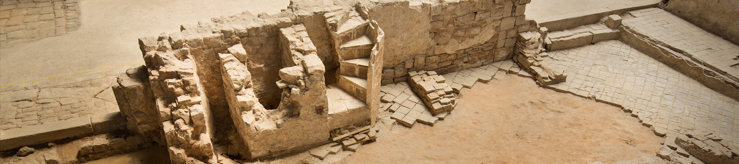
The archaeological remains that have been excavated and which can currently be seen inside the old El Born market show us the history of Barcelona from the Roman period up to the start of the 18th century, where life in this part of the city was abruptly interrupted with the outbreak of the War of the Spanish Succession.
Not all the remains are of the same importance or have been conserved to the same extent. We need to bear in mind that the relics conserved prior to the 13th century were not part of Barcelona’s urban centre, even though they were linked to it. By contrast, from the 13th century on, the structures already fully belonged to the city, as a result of its growth.

Third century AD.
Roman era
Despite being located far from the city of Barcino, the El Born area preserves burials from the Roman period in its subsoil.
The first archaeological remains documented in the areas nearby El Born date back to the early empire period. An extensive burial site from that period has been found, whose main part stood inside what would become, centuries later, the Santa Maria del Mar’s subsoil. No burial from this period has been located inside the old market, though the archaeological work on Plaça Comercial in 1991 found four burials.
Third century.
Muslim era
The area that the old El Born market was built on had been occupied by a Muslim burial site
The second stage possibly dates it back to the 8th century. This is a new burial site located between the current Plaça Comercial and the old El Born market. Archaeological work in 1991 led to the identification of seventeen burials and a further two were documented from excavation work inside El Born between 2001 and 2002.
All burials present the same features repeatedly: burials directly in the sand in a simple ditch, without any grave goods or archaeological element in their surroundings (such as ceramics or iron keys), with the body invariably lying on its lateral right side and facing the same south-west – north-east direction, with the feet aligned along the latter and the head along the former, with the facial skeleton facing south-east.
All the burials’ features coincide with the burial sites that follow the Islamic custom. Until 14 are carbon dated, we shall never know whether these burials date back to Barcelona’s Muslim occupation or simply concern individual Muslims living in the city before the 13th century.
Third century
The Medieval city
The first documentary reference giving information on buildings in an area nearby El Born date back to the 10th century, when El Rec Comtal was built, a key piece in the development of this part of the city. Barcelona’s trade centre was established in this sector between 1050 and 1250, when both the city and its suburbs underwent considerable growth. The population occupying the eastern part become increasingly important and Santa Maria de les Arenes supported a wide sector known as Vilanova del Mar, which extended through the north to the area around the Sant Cugat del Rec church. This area had already become the city’s most active section from the 13th century on. This is a large area of narrow parallel streets, which continued to extend outward as the sea moved back and its land was reclaimed. This first centre formed the origin of the future La Ribera neighbourhood which later on came to occupy both sides of El Rec. La Ribera underwent constant urbanisation throughout the 13th and part of the 14th centuries. It was finally established when the Sant Agustí convent was built along the section of the city wall between the Nou i Santa Clara gate and the Santa Maria del Mar church. All the documented houses and streets in the El Born archaeological site date back to the end of the 13th century and start of the 14th. The neighbourhood grew rapidly, its urban planning had nothing to do with its adjacent neighbourhoods, housing blocks were arranged regularly, with straight and parallel streets, seeing that in most cases the urban section did not have to adapt to any pre-existing structure which would limit the shape of the streets and blocks. A notable exception can be seen inside El Born, however: west-facing housing blocks were adapted to the El Rec Comtal route, which had already become an established feature by the time this part of the neighbourhood was urbanised.
The first documentary reference giving information on buildings in an area nearby El Born date back to the 10th century, when El Rec Comtal was built, a key piece in the development of this part of the city. Barcelona’s trade centre was established in this sector between 1050 and 1250, when both the city and its suburbs underwent considerable growth.
The population occupying the eastern part become increasingly important and Santa Maria de les Arenes supported a wide sector known as Vilanova del Mar, which extended through the north to the area around the Sant Cugat del Rec church.
This area had already become the city’s most active section from the 13th century on. This is a large area of narrow parallel streets, which continued to extend outward as the sea moved back and its land was reclaimed. This first centre formed the origin of the future La Ribera neighbourhood which later on came to occupy both sides of El Rec.
La Ribera underwent constant urbanisation throughout the 13th and part of the 14th centuries. It was finally established when the Sant Agustí convent was built along the section of the city wall between the Nou i Santa Clara gate and the Santa Maria del Mar church.
All the documented houses and streets in the El Born archaeological site date back to the end of the 13th century and start of the 14th. The neighbourhood grew rapidly, its urban planning had nothing to do with its adjacent neighbourhoods, housing blocks were arranged regularly, with straight and parallel streets, seeing that in most cases the urban section did not have to adapt to any pre-existing structure which would limit the shape of the streets and blocks.
A notable exception can be seen inside El Born, however: west-facing housing blocks were adapted to the El Rec Comtal route, which had already become an established feature by the time this part of the neighbourhood was urbanised.
1701 - 1715
The War of the Spanish Succession
The War of the Spanish Succession marked a turning point in the history of the country and Barcelona lost a vital part of its territory.
No notable changes have been documented in the entire archaeological area of El Born until the end of the War of the Spanish Succession. This armed conflict between two pretenders to the Spanish monarchy shaped the future of the country and the city. The former kingdoms of Aragon and Castille supported the Habsburg Archduke Charles and the Bourbon Philip respectively. The conflict become an international one when other European powers took part in it, ending on 11 September 1714 with the fall of Barcelona.
Once the war was lost, its winners decided to build a military citadel serving a twofold purpose: defending the city along one of its weakest points and repressing its citizens. This is a pentagonal star-shaped fortress with five bastions at each of its angles, two of which point directly to the city. The Citadel needs a security area where it is open to the city, an esplanade where there can be no building of any kind and which allowed the troops to sally out in case of a revolt in the city.
Pròsper de Verboom, the military engineer commissioned with designing the Citadel, originally marked out the line for demolishing houses up to Santa Maria del Mar (all that was found in a rifle shot), but that demolition line was subsequently pulled back definitively to the boundary marked out by C/ Tiradors, C/ Blanqueria, C/ Corretger, C/ Sabateret, C/ Flassaders, Plaça del Born and C/ Montserrat. This is a very important Barcelona area, both in its size (295,705 m2) and in being one of the most economically significant and highly populated areas of the city.
A thousand houses were pulled down between April 1716 and July 1718, forty-two streets disappeared (five of which partially), twenty per cent of Barcelona’s population were moved and fourteen buildings including heritage elements from the church, public buildings and facilities were destroyed. The El Born archaeological site is a highly representative sample of all the houses and streets that were pulled down.
The Bourbon authorities forced their owners to pull down their own houses (or pay for their demolition) and Barcelona’s carpenters and house builders to take part in building the Citadel, receiving a miserable salary of five sous a day, carrying out a minimum of forty journeys, as they would not have otherwise received any payment.
Verboom proposed a system for compensating the owners of the houses: giving them plots of land in the agricultural fields of Sant Pau or on the beach, a financial contribution and the possibility of taking the materials of the demolished houses. The reconstruction of La Ribera neighbourhood in Sant Pau proved to be a failure as did the neighbourhood of the beach, seeing that most of the population was redistributed along the actual La Ribera and surrounding neighbourhoods.
The demolition was carried out in three stages; from April 1716 to April 1717, from April to September 1717; and finally the third stage which ended in July 1718. The aim behind pulling down the houses was to regularise the esplanade by levelling out its area between the Citadel and Plaça del Born, which is why there was no need to pull down houses as far as their foundations in the most depressed areas, thereby halting the demolition at the level marked out by the military engineers. This would explain the extraordinary state of preservation of El Born’s archaeological area, with walls of up to over two metres in height at many points in the site.
If the area the old El Born market occupied at the time of the demolition had been the same level as Plaça del Born, the archaeological site today would have looked completely different. The archaeological structures preserved (in some of the areas) were practically levelled during the archaeological work in 1991 on Plaça Comercial.